The North American Monsoon got an early start in northern Arizona this year with copious amounts of precipitation over the San Francisco Peaks and surrounding areas. Unfortunately, we are now experiencing an extended monsoon break with mostly clear skies and hot temperatures.
Here are some photograph taken during that wet period.
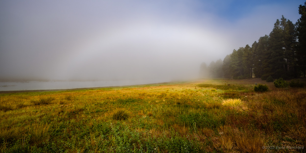
A partial rainbow over Upper Lake Mary near Flagstaff, Arizona.The rainbow is gone but sunset colors are seen in the clouds and the reflection in the lake.A partial rainbow over the grasslands of Wupatki National Monument.A zoomed-in segment of the rainbow showing supernumary bows.Sunset at Wukoki Pueblo in Wupatki National Monument.
Here are the June rainfall totals from the Flagstaff rain gauge network.
June rainfall totals for the Flagstaff raingage network.
A few days ago we had a cold front move across the area and overnight temperatures fell below freezing for a few hours in the higher terrain. It turns out that October is a good month for fog formation from these first frontal incursions. Area lakes still have relatively warm water from the recently ended summer. The passage of the cold air over the warm water allows for increased moisture flux from the warm water into the colder air that increases the dewpoint (and relative humidity) and can result in fog. Also, the shorter days–and longer nights–allows radiation fog to develop in the valleys.
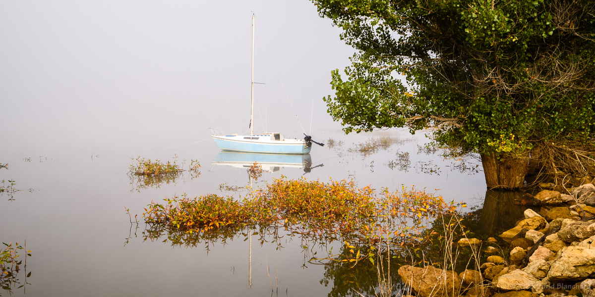
Fog in the Mormon Lake basin with a colorful but diffuse glory.A small sailboat lies at anchor on a foggy morning at Upper Lake Mary.Fog and Upper Lake Mary.
With that in mind, I found myself driving past Lake Mary to Mormon Lake before sunrise on Tuesday morning. As I approached Lake Mary visibility dropped quickly to 1/4 mile, then 1/8 mile, and then 1/16 mile. Visibility improved once I passed both Lower and Upper Lake Mary. At Mormon Lake, there was fog swirling in the basin and the rising Sun was just starting to illuminate the summits of the San Francisco Peaks.
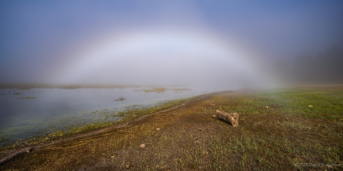
Fogbow over Upper Lake Mary.Fogbow over Upper Lake Mary.
After the fog dissipated in Mormon Lake, I returned to Lake Mary where the fog was still present and I was able to capture fogbows plus a nice photo of a sailboat anchored in the lake.
Time-lapse video of the swirling fog in the Mormon Lake basin.
Time-lapse video of the swirling fog and glory in the Mormon Lake basin.
The time-lapse videos show remarkable motion of the swirling for over Mormon Lake as well as the colorful but diffuse glory that was present.
(1) Steam fog (arctic sea smoke). Steam fog forms when water vapor is added to air that is much colder, then condenses into fog. It is commonly seen as wisps of vapor emanating from the surface of water. This fog is most common in middle latitudes near lakes and rivers during autumn and early winter, when waters are still warm and colder air masses prevail.
(2) Radiation fog (ground or valley fog). Radiational cooling produces this type of fog. Under stable nighttime conditions, long-wave radiation is emitted by the ground; this cools the ground, which causes a temperature inversion. In turn, moist air near the ground cools to its dew point. Depending upon ground moisture content, moisture may evaporate into the air, raising the dew point of this stable layer, accelerating radiation fog formation.
This Winter has been relentless with snowfall now at about 200% of normal for Flagstaff. Many of these storms have made it difficult to get to various locations for shooting photos of the weather. Fortunately, the last few storms have allowed me to do some pre-dawn travel to favorite locations.
The first two photos are from the morning of 16 March 2023 when I thought there was a good chance of low clouds and fog in Grand Canyon. In fact, there was too much fog and I was only able to briefly see into the canyon while at Lipan Point. I finally moved westward to Moran Point where there was a larger break in the fog allowing sunlight to illuminate the canyon.
Early morning fog in Grand Canyon from Lipan Point.Early morning fog in Grand Canyon from Moran Point.
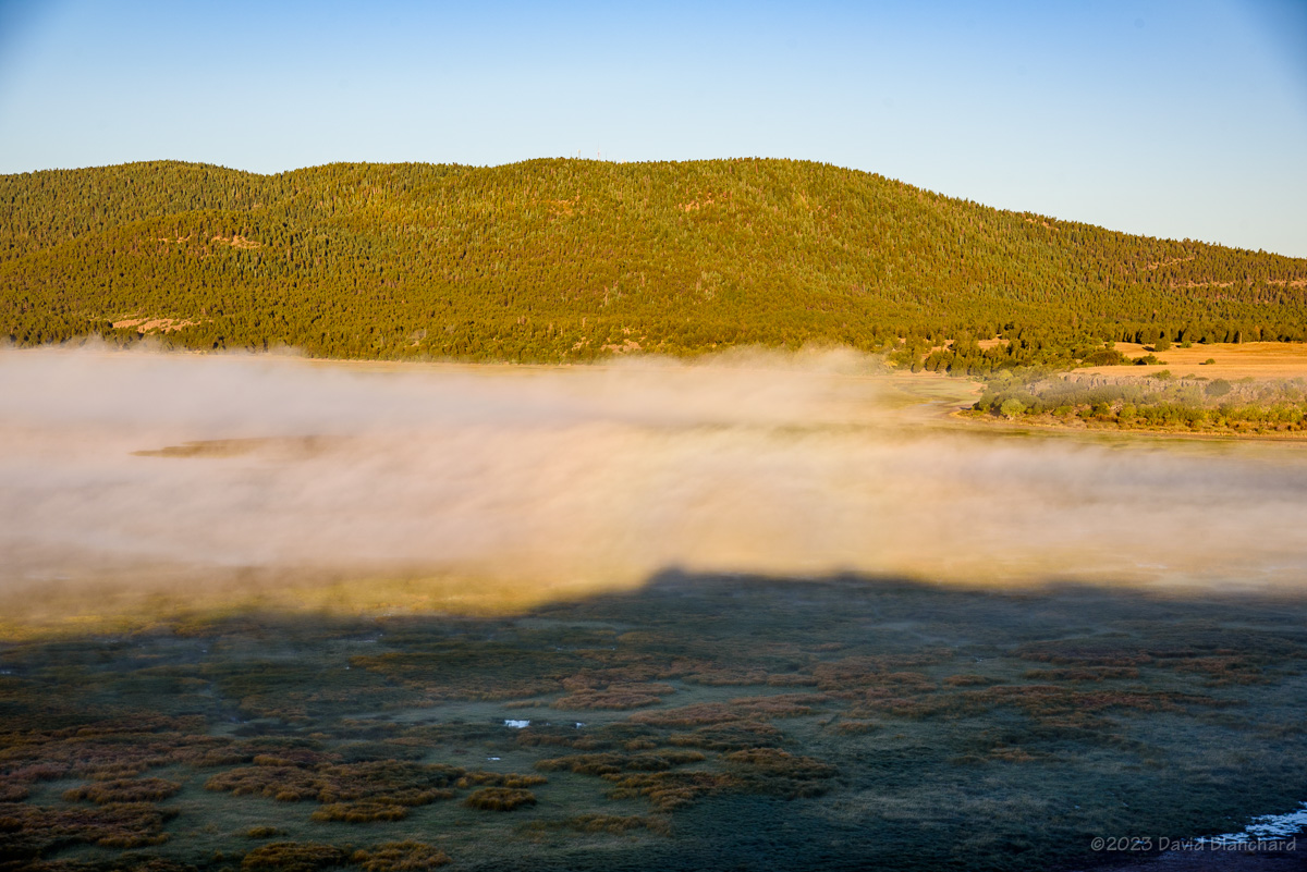
A week later we had a snow-turning-to-rain event that left the roads relatively easy to travel and I ventured out to Mormon Lake on the morning of 23 March 2023. The abundance of moisture over the previous few days resulted in lots of fog in low-lying basins including Lake Mary and Mormon Lake. Clear skies to the east allowed the rising sun to illuminate the San Francisco Peaks in the distance.
The distant San Francisco Peaks rise above fog filling Mormon Lake basin.Fog fills Mormon Lake Basin. A faint Glory is seen left of center while a short segment of a fogbow is right of center.A fogbow along Upper Lake Mary.
I was also interested in capturing images with a Glory/Brocken Spectre and fogbows. Both were faintly visible in some of the photos where I was above the fog. A better fogbow photo was shot when I was in the fog.
And here is a time-lapse video of the swirling fog in the Mormon Lake basin.
Time-lapse video of fog swirling in Mormon Lake basin.
The medium-range forecasts indicate that Winter is not yet done.
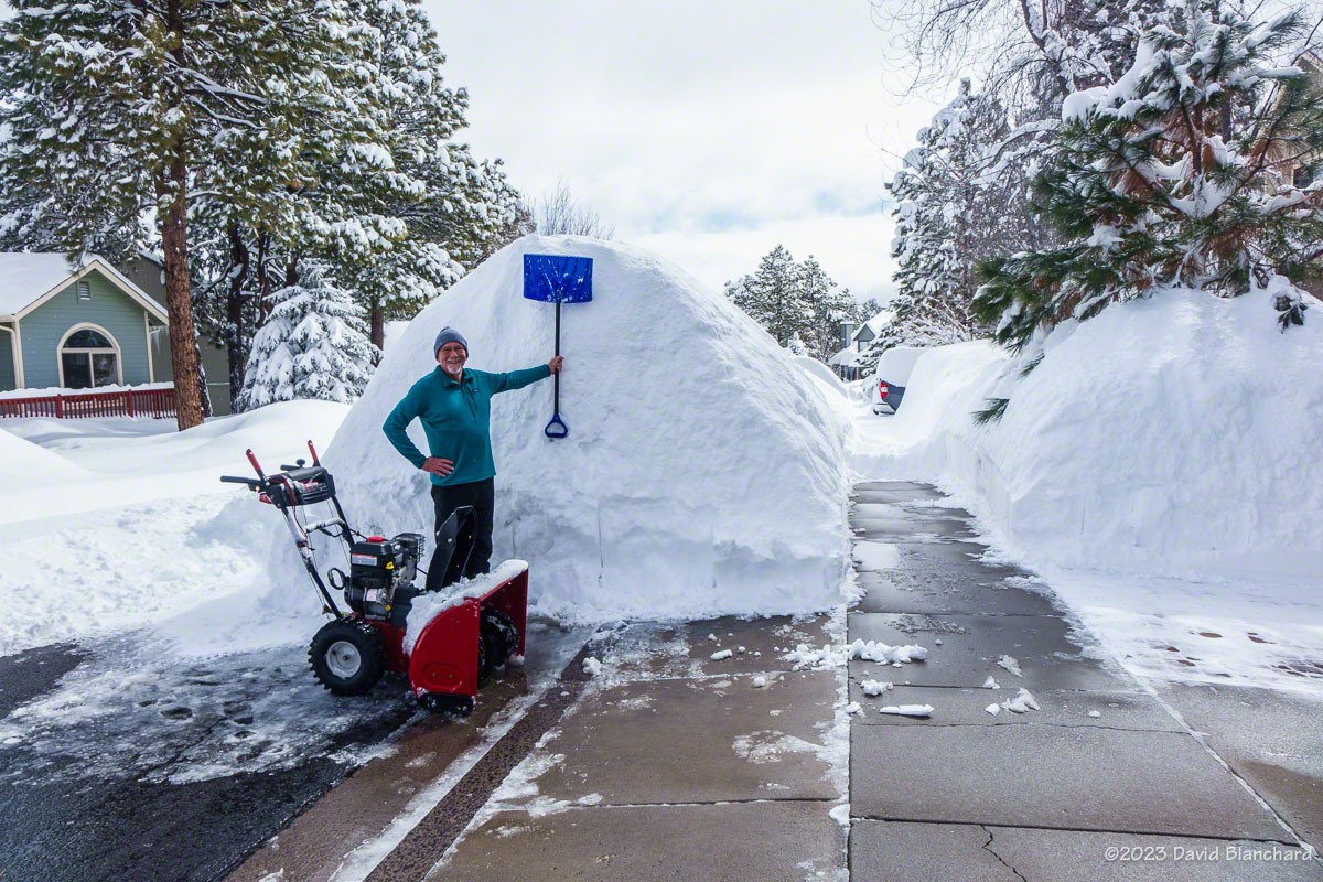
This has been an exceptional winter for snowfall. Currently, we are in the top 10 for all-time snowfall amounts and we still have a month (or more) to go. This much snow brings a lot of work clearing the driveway, sidewalks, and even the roof.
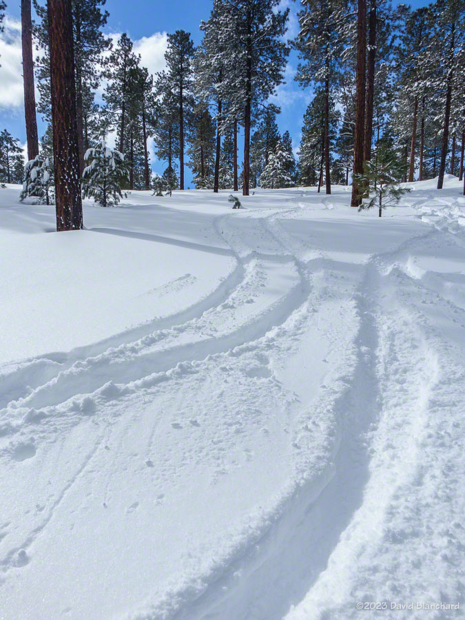
But there is an upside and we get to ski. An earlier post showed a day spent on the San Francisco Peaks. There are also some nice trails and small hills closer to our home and we have found ourselves skiing this gentle terrain several times this winter.
Heading out of Fort Tuthill County Park.Outside the boundaries of the park are a few small hills that allow us to get in some downhill runs on our skis.We just go up and down a bunch of times.But first we have to dig ourselves out and clear the driveway. Note that the road is not yet cleared.Sidewalk tunnels.This chart shows that we are having an “Extreme Winter” in Flagstaff.
This chart shows that we are having an “Extreme Winter” in Flagstaff.
Fortunately, we are experiencing a break in the winter storm pattern and the warm temperatures are melting the snow. But it will take time.