It’s been an interesting fall around here with regards to precipitation. The December statistics for Flagstaff are interesting. Up through 12/29/2014, there had been 2.75″ of water equivalent (both rain and melted snow). Normal for this period is 1.60″. Snowfall, on the other hand, has been mighty scarce. There had been a total of 4.9 inches this fall/winter; normal should be closer to 26 inches. What a difference!
But all that changed dramatically with the arrival of a strong and cold winter storm on New Year’s Eve day and continuing into the New Year’s Day. Snow levels fell to very low elevations with this storm and photographers were flocking to their favorite locations to capture amazing images of the desert with snow. Even Phantom Ranch, at the bottom of the Grand Canyon, received some snow from this storm.
An interesting aspect of this event was the cold front that pushed southward across the Great Basin and brought frigid air to southern Utah and northern Arizona just before the storm arrived. Then, when the precipitation began it fell into very cold air—and did not melt—resulting in snow accumulations around the very low elevations of Lake Powell and Page. This location is well known for being highly photogenic and the addition of snow makes it even better.
Closer to home, significant snow fell in Flagstaff (16-20 inches), Oak Creek Canyon, and Sedona. In fact, folks suggest this may have been the most snow from a single storm in several decades with 8-10 inches decorating the famous Red Rock Country.
And it was an amazing sight when the sun finally broke through the clouds.
Pillows of snow covers the rocks in Oak Creek.Snow decorates the red rock in Sedona, Arizona.Coffeepot rock in Sedona, Arizona.Cathedral Rock and the reflecting pools.Cathedral Rock reflected in Oak Creek.Sunset colors splash across the tree tops, red rocks, and snow in Sedona, Arizona.The Kachina Peaks with a rising moon from Garland Prairie, Arizona.Moonrise behind the Kachina Peaks .Moonrise behind the Kachina Peaks along with Earth Shadow and Belt of Venus.
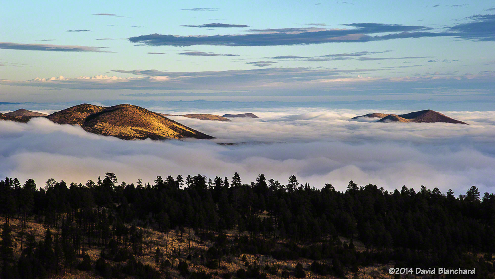
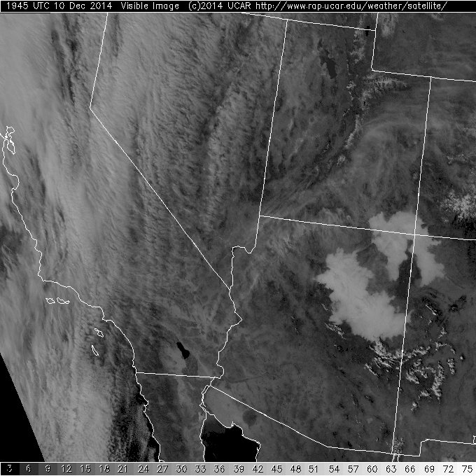
Widespread, dense fog covered portions of northern Arizona for more than a week in early December. The fog appeared at Winslow, Arizona (KINW), during the evening of December 3 and finally dissipated on the afternoon of December 12. Similar conditions were experienced in Flagstaff, Arizona (KFLG), with fog appearing on the afternoon of December 4 and finally dissipating in the evening of December 10. For some locations, including Flagstaff, the fog was episodic with periods of dense fog interspersed with clear conditions. Farther to the northeast, including places such as Winslow and the Chinle Valley, the fog was more persistent.
A sea of fog across northern Arizona at sunrise.
The fog was the result of a heavy rainfall event across northern Arizona December 2–4. Many locations received between 1 and 2 inches of rain. Following the rain, high pressure developed across the southwest and a strong thermal inversion developed. The inversion was finally removed when a trough moved across the region bringing strong southwest winds and steeper lapse rates.
Visible satellite image showing extensive areas of fog across northern Arizona.
It should be noted that thermal inversions are not rare. Quite the contrary. An inversion commonly occurs at night and during the winter when the angle of the sun is very low in the sky. After last years fog event in the Grand Canyon, some in the media declared that thermal inversions are rare and that the inversion was the cause of the fog. Not really. Both then and now the moisture evaporated out of the soils but was trapped near the ground by the inversion. And, slowly but surely, the moisture content of the lowest few hundred meters of the atmosphere became saturated and fog developed.
Well—enough of the meteorological explanation. What did it look like?
When these shallow fog events occur it is possible to find hills and mountains that are above the inversion so that an observer can look down on the fog. This often results in some amazing photographic opportunities. Anticipating that the fog would occur, I was ready to travel to the Grand Canyon to capture images of the fog filling the canyon. Well, it didn’t quite fill the canyon—at least, not like last year. But there were still photographic opportunities.
I also found myself on the lower slopes of the San Francisco Peaks north of Flagstaff and was able to capture images and video of the fog streaming across the pass between the San Francisco Peaks and O’Leary Peak as well as the sea of fog across the Little Colorado River Valley.
It’s been a dry autumn in northern Arizona but a recent storm brought moderate rainfall amounts to much of the area. This was greatly appreciated as the trails were becoming dry and dusty and wildfires were beginning to pop again.
But even more important—from the perspective of a photographer—was the possibility of fog across northern Arizona, especially in and near the Grand Canyon. Last year, a major rain event resulted in a moist boundary layer that persisted for many days and led to widespread fog and a very photogenic fog event in the Grand Canyon.
The possibility existed that this could happen again so early Friday morning I arose before dawn and checked the weather conditions. Everything looked good so I drove up to the South Rim of the Grand Canyon. The best fog was located in the Little Colorado River valley and to the east of the Grand Canyon. The fog was slowly pushing westward and then spilling over the edge of the canyon and evaporating as it descended.
A Glory and Brocken Spectre in the depths of the Grand Canyon.
Slowly the canyon began to develop fog within the depths that would at times race upwards to the rim. When these patches of fog were located directly opposite the direction of the sun, a Glory and Brocken Spectre would appear. I was shooting images with a 10 second interval and assembled these into a short video showing the fog spilling over the edge as well as the appearance and disappearance of the glory several times.
Grand Canyon fog.
Low-level moisture remains plentiful across the region and with the development of a large area of high pressure aloft and a thermal inversion the chances of fog in the Grand Canyon will continue for the next few days.
With autumn winding down and winter just around the corner in northern Arizona, it was our last chance to attempt a Rim-to-Rim-to-Rim (R2R2R) hike across the Grand Canyon. Several years ago we tried the R2R2R but strong winds drove us back as we neared the North Rim. Although we were only about 3-1/2 miles from the finish, it was the prudent thing to do. Later that year, we tried again but a problem with my iliotibial band turned us around after only a few miles and we settled for a shorter hike.
Jump forward a few years and the knee issues have gone into remission. With fine weather expected and the moon just a few days past full it was time to try again.
We left the South Rim on the South Kaibab Trail (elevation 7260′) at midnight with a temperature in the low 40’s and 20–30 mph winds. Hats, gloves, and vests/parkas were required for this initial descent. At times, the wind was so fierce that we wondered if we should continue. By the time we had descended to Cedar Ridge (6060′) the wind had diminished enough to allow us to shed some of the excess gear.
With the bright moon high overhead and headlamps we were able to easily travel downhill. Traveling in the dark with a bright moon and no other hikers around is an amazing experience. It’s so quiet! We traveled quickly and arrived at the Colorado River (2480′) at 3:30 a.m. Temperatures were in the low 60’s and we took a long food and water break at Phantom Ranch before starting up the North Kaibab Trail through Bright Angel Canyon.
First light high on the canyon walls.
A short distance up stream from Phantom Ranch is “The Box.” Traveling through The Box can be the hottest part of the hike with its high and close walls of granite but it was still dark and pleasantly cool as we traversed this section of Bright Angel Canyon. The last time we were here, spring snow melt had resulted in so much water rushing down the creek that boulders were constantly moving, grinding, and crashing into each other underwater resulting in a raucous cacophony of sound. Not tonight; the gentle flow of water resulted in a delightful sound that was mesmerizing in the dark.
North Kaibab Trail in Roaring Springs Canyon.
We arrived at Cottonwood campground (4080′), about 8 miles from Phantom Ranch, shortly after sunrise. We learned that the water had already been shut off for the season which meant there might not be any drinking water available uphill from here. Luckily, water was still running at the Roaring Springs Pumphouse Residence (~5200′) and we refilled here.
Supai Bridge on the North Kaibab Trail in Roaring Springs Canyon.
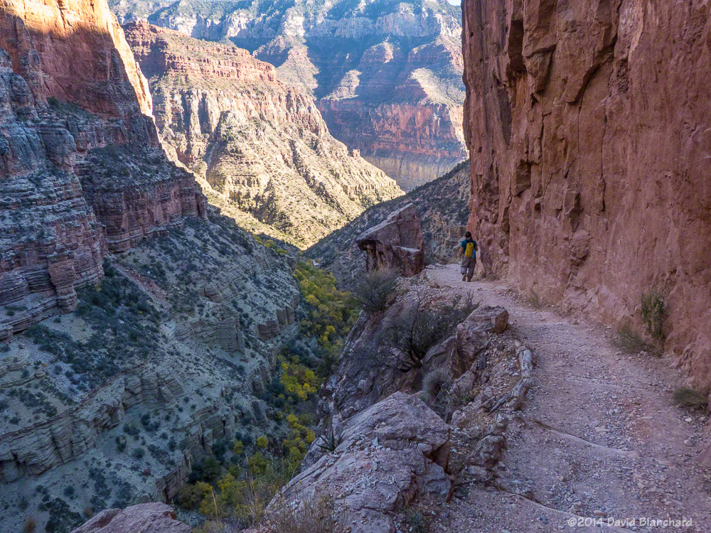
From Phantom Ranch to Roaring Springs Residence the North Kaibab Trail is a gentle uphill climb. The trail leaves Bright Angel Canyon just past the Residence and ascends Roaring Springs Canyon which is a much steeper section of trail. The trail is narrow and perched on a nearly vertical wall with steep drops to the side. It can be very intimidating.
Supai Bridge in Roaring Springs Canyon as seen from North Kaibab Trail.
The trail crosses the narrow canyon at Supai Bridge and begins a series of steep switchbacks to the top. Along the way, you pass through Supai Tunnel (6800′). Not surprisingly, the water here had been turned off for the season. We arrived at the North Rim (8240′) at 12:15 p.m., where we had a leisurely lunch. Already very tired from the long climb, we now had to reverse and do it in the opposite direction.
Coconino Overlook on the North Kaibab Trail.
As we descended Roaring Springs Canyon we stopped often to take photographs as the light was much better in the afternoon than it had been in the morning. The trees in the bottom of the canyon were still showing autumn colors and the narrowness of the trail as it hugged the canyon cliff was much more impressive. We stopped again at the Residence to refill our water bottles, drink, eat, and rest.
Narrow trail and steep cliffs in Roaring Springs Canyon.
Darkness descended upon us down canyon from Cottonwood Campground and, once again, we traversed The Box in the cool darkness, arriving at Phantom Ranch at 8 p.m. Many campers were hanging around waiting for the cantina to re-open so they could visit the bar. I was definitely interested in a beer but thought better of it. Instead, I lay down on the picnic bench to rest and, not too surprisingly, fell asleep, awakening around 9 p.m.
Narrow trail, steep cliffs, and autumn colors on the trees in Roaring Springs Canyon.
After drinking lots of water, consuming as many calories as we could, and filling our water bottles, we departed Phantom Ranch around 9:30 p.m. and began the long and steep climb back up South Kaibab Trail. Clouds during the evening prevented us from getting any useful moon light so we were on headlamp lighting only. Once again, winds became strong and gusty as we ascended and we donned the warmer clothing.
Finally, at 3:15 a.m., we arrived at the South Rim. It had taken us 27 hours and my goal had been 24 hours. Although I was slightly disappointed at how slow we had traveled I was very happy that my third attempt at R2R2R had been successful. Total: 42 miles and 10,540 feet of ascent.
There was a partial solar eclipse October 23, 2014, that was visible across most of North America. Patches of cirrus clouds moved across the sky all day but the sun was always visible. To safely view the eclipse, we donned our solar eclipse glasses and sat back to enjoy the show. At our location, the maximum coverage was about 50% of the solar disk.
This photo was taken using a Panasonic Lumix FZ150 zoomed to 600mm (equivalent) focal length with an ND3 neutral density filter. The ND3 reduces incoming light by 10 stops. Even with the filter, I had to shoot at f/8 (the smallest aperture for this camera and a shutter speed of 1/2000 second at ISO 100 to get a reasonable exposure.
The large sunspot near the center of the solar disk is AR2192—the largest sunspot in several decades. The combination of solar eclipse and massive sunspot made for an interesting image.