Thunderstorms and Tornadoes in Arizona

A potent weather system moved across Arizona on Tuesday, October 5, 2021, and produced a variety of weather including tornadoes, large hail, heavy rain, and flooding. This system was well forecasted and the various models did a very good job depicting the possibilities.

Radar-estimated rainfall amounts across Arizona on Tuesday morning.

Areas of moderate rain moved across Arizona in the pre-dawn hours with many locations receiving more and one inch of rain by sunrise.

There had been some expectations that the severe weather would commence before sunrise owing to the favorable vertical wind profiles. Both the low-level shear and deep-layer shear supported organized thunderstorms with the possibilities of rotating supercells and even tornadoes. That scenario did not manifest probably because the widespread overnight rain cooled the boundary layer enough to inhibit strong thunderstorm development.

The forecast models also suggested a second period of severe weather was possible in the afternoon as temperatures warmed and buoyant instability increased across the area.

Severe thunderstorm with a Three-Body Scatter Signature (TBSS; also known as a "hail spike").
Severe thunderstorm with a Three-Body Scatter Signature (TBSS; also known as a “hail spike”).
Severe thunderstorm with a hook echo (left) and strong velocity couplet (right). The box indicates that a Severe Thunderstorm Warning is in effect for this storm.
Severe thunderstorm continues to show a hook echo (left); on the right is Correlation Coefficient where low values may indicate tornadic debris. The warning has been upgraded to a Tornado Warning.

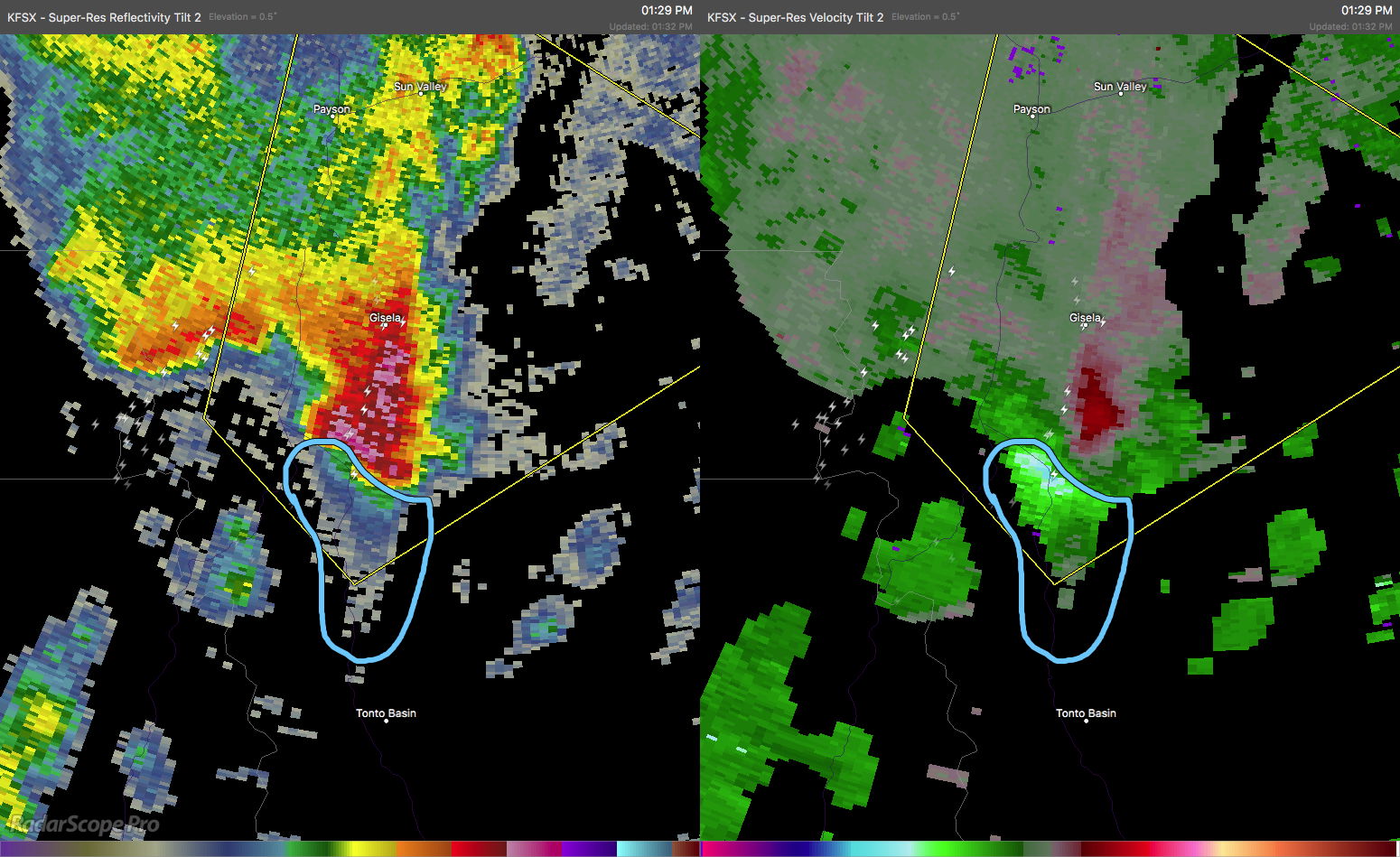
Strong thunderstorms developed across the desert regions of central and southern Arizona in the afternoon. These moved quickly to the northeast and into the higher terrain of the Mogollon Rim and Tonto Rim. At least two of these thunderstorms began to acquire supercellular characteristics and began to show rotation signatures in the Dopper radar data. By mid afternoon, one storm had developed a well-defined hook echo and velocity couplet. This storm was already producing strong winds and hail and a Severe Thunderstorm Warning (SVR) was already in effect. As the rotation rapidly intensified, the SVR was replaced with a Tornado Warning (TOR). Polarimetric Dopper radar data indicated low values of Correlation Coefficient (CC). This often accompanies tornadic debris lofted into the air. This was clearly a dangerous storm and the TOR was justified.

Multi-Radar Multi-Sensor (MRMS) depiction of large hail swaths.
MRMS rotation tracks associated with the tornado.

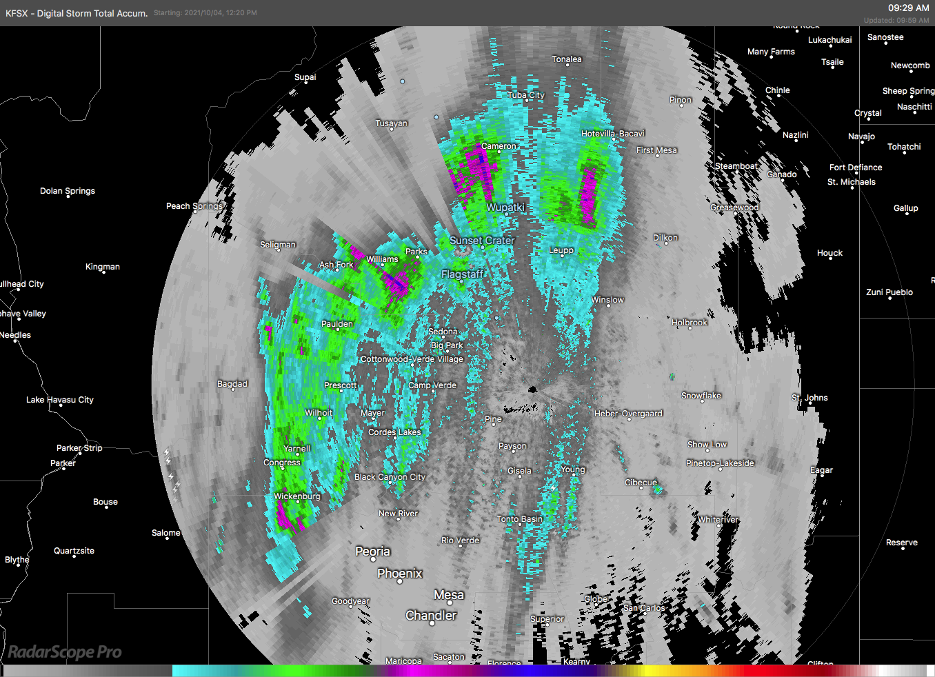
Eventually, the rotation weakened but the storm was still producing large hail as it moved northeastwards. Other storms also produced large hail. The Multiple Radar Multiple Sensors (MRMS) data shows these long swaths of large hail across portions of Arizona.

Forecasters from the National Weather Service offices in Arizona did a great job of anticipating this severe weather event and issuing timely warnings.

Storm Chasing and Photography — Spring 2018

Cumulonimbus Mammatus over Wyoming grasslands.

03 June 2018

We left Flagstaff yesterday and spent the night in Albuquerque and today we will drive the rest of the way to Denver. We will be spending two weeks in Denver visiting family and friends—and will do a bit of storm chasing if the right conditions present themselves.

We had dinner last night at the Owl Cafe—a Route 66-style diner. We’ve been here before and like the decor. The food isn’t too bad, either.

The drive from Albuquerque to Denver was interesting as we were in a post-frontal airmass and the clouds had these abstract undulations. We stopped a few times for photos along US 84 in eastern New Mexico.

Owl Cafe interior.
Owl Cafe interior.
Owl Cafe interior.
Owl Cafe interior.
Windmill and clouds in eastern New Mexico.
Gate and clouds in eastern New Mexico.

Continue reading →