Storms in August were more plentiful than in July although there were still some extended breaks in the monsoon. Rainbows remained elusive for me. I was able to photograph a few that displayed short segments but I never captured a full rainbow. Lightning, on the other hand, was plentiful and I did well in that genre.
Here is a partial summary of August monsoon photography.
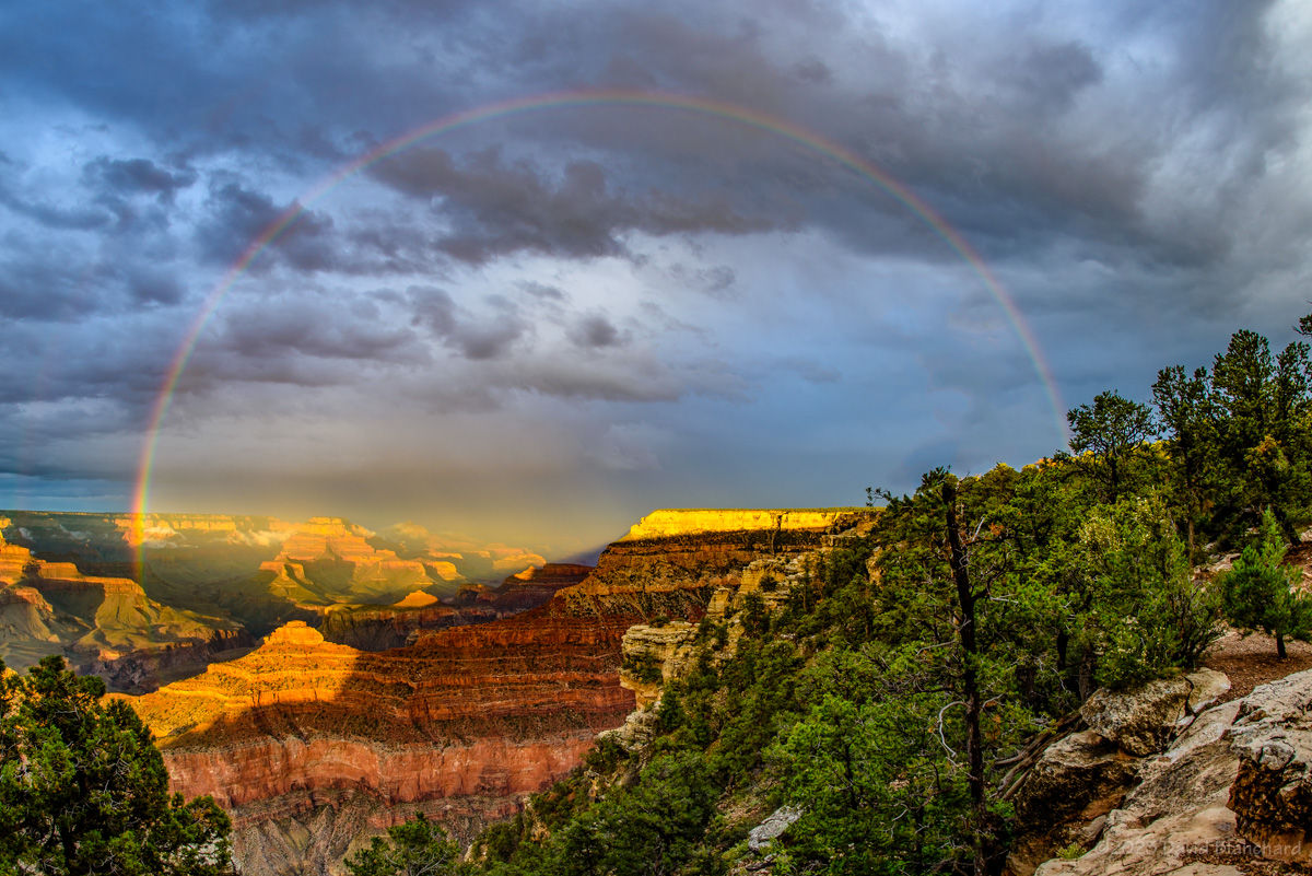
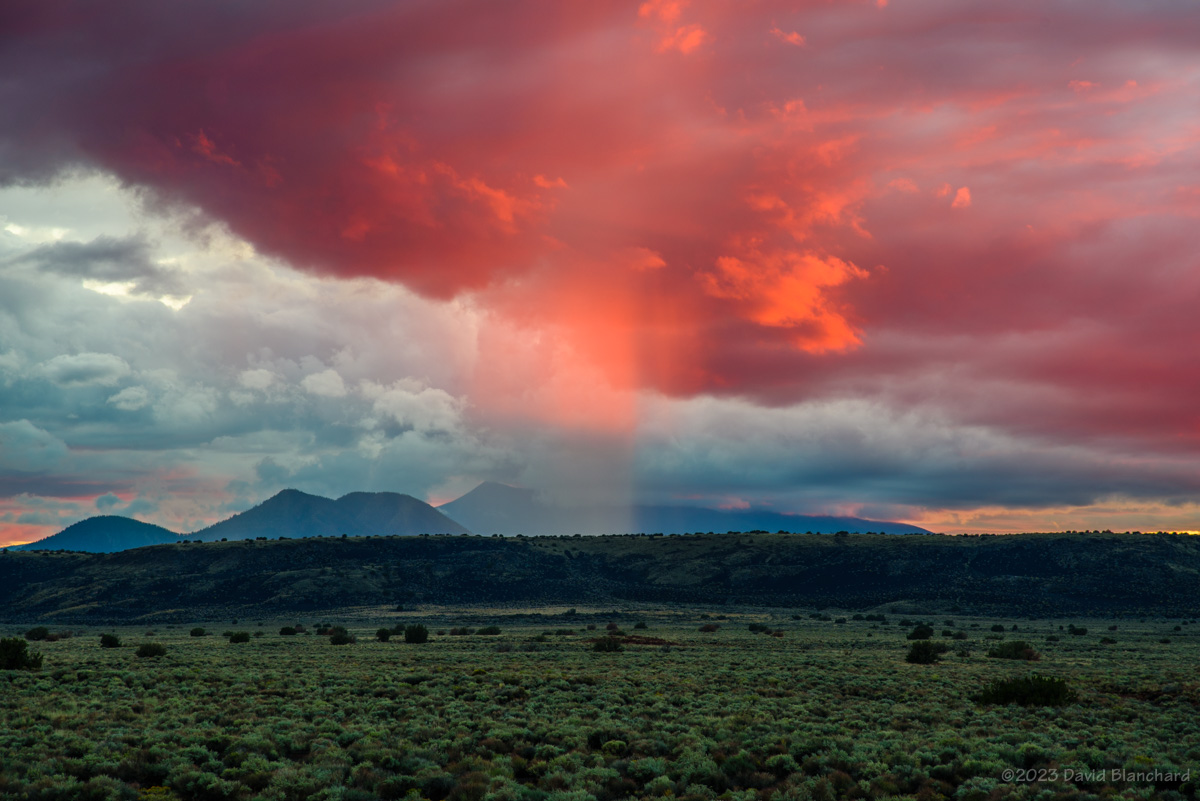
04 August 2024
Mormon Lake Overlook is a short drive from Flagstaff and affords an amazing 360° view. This was one of the many days with only a partial rainbow but the juxtaposition of the rainbow and the tree in the grasslands of Anderson Mesa was a pleasing composition. A few minutes later the Sun beautifully illuminated some light rain falling from a dissipating thunderstorm. The color was intense and only lasted a few minutes.
A short segment of a rainbow above the grasslands of Anderson Mesa in northern Arizona.A curtain of light rain from a dissipating thunderstorm is brilliantly illuminated by the setting sun.
After an early start to the monsoon in late June, the monsoon went on an extended break. For much of July, high pressure remained to our west resulting in northwest to northeast flow across the region. Consequently, tropical moisture had to take the long route over the eastern Pacific Ocean, across the Pacific Northwest, then southward across the High Plains and Rocky Mountains. By the time it arrived, much of the moisture had been depleted, especially in the lower levels. The resulting storms were generally weak and produced little rain, and even less lightning.
Here is a summary of what I did manage to photograph during that period.
11 July 2024
Weak storms produced little in the way of rain but did result in a nice sunset.
Sunset and reflected sunlight on Lake Mary.
15 July 2024
A few strong storms formed on the north side of the San Francisco Peaks and I positioned myself at the entry to Wupatki National Monument. There was very little lightning but I did get this photograph that shows the landing point of the bolt. I also got power poles.
Lightning on the north side of the San Francisco Peak showing the landing point of the bolt.
16 July 2024
Radar indicated some storms south of Mormon Lake–a favorite spot for shooting storms because of its expansive views. This storm produced only a few visible bolts of lightning but I did manage to capture this one–along with the waxing gibbous Moon.
Distant thunderstorm with lightning.
21 July 2024
While taking a short hike to Alfa Fia Tank near Snowbowl and the San Francisco Peaks I was happy to see some convection developing that had nice reflections in the water. Look closely and you will also see the ducks.
Reflection of developing storms in Alfa Fia Tank near Snowbowl in the San Francisco Peaks.
23 July 2024
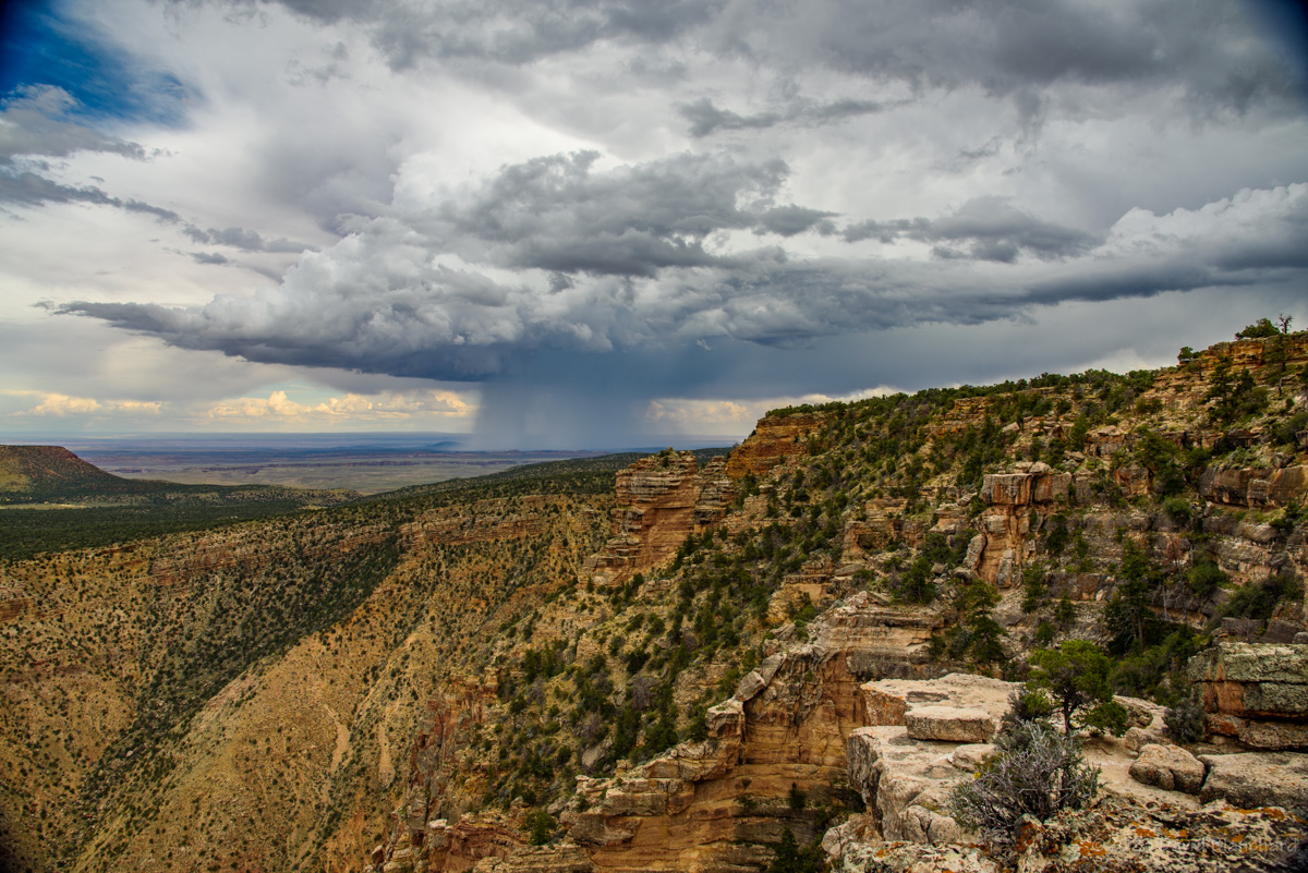
I was confident that Grand Canyon would produce good storms with possibilities for lightning and rainbows. It didn’t. The best I could do was shoot this ultra-wide view of the clouds using a 12mm fisheye lens.
Ultra-wide angle view of Grand Canyon from Navajo Point.
24 July 2024
The next day in Sedona was a bit better. Although there was some lightning I managed to miss it all because it was never in the direction that the camera was pointed. Look carefully in the upper left corner of this image and you can just barely see a few filaments of the lightning stroke which occurred to the left of the camera. I should have shot this with a wider field of view. On the other hand, the sunset was pretty good.
Heavy rain falling from a monsoon thunderstorm.Another great sunset in Sedona, Arizona.Sunset in Sedona.
26 July 2024
A few days later I tried something different and concentrated on getting the very early stages of convective development over the San Francisco Peaks. A bonus was catching the reflections of the clouds in Marshall Lake. By the time I left there was lightning and I was able to capture a few bolts.
Reflection of developing clouds in Marshall Lake, Arizona.Reflection of developing clouds in Marshall Lake, Arizona.Lightning over Marshall Lake with the San Francisco Peaks in the distance.
Time-lapse of convection developing over the San Francisco Peaks (200x speed).
While shooting these still images I had another camera capturing time-lapse video. It’s always fun to see the development of clouds in time lapse.
26 July 2024
This was a last-minute decision as the radar showed storms developing west of Flagstaff. I drove to Mormon Lake hoping for sunsets, rainbows, and lightning. Two out of three isn’t bad.
Sunset colors on thunderstorms and anvil clouds.Lightning west of the San Francisco Peaks.In-cloud lightning in the anvil of a thunderstorm.Lightning from a distant storm located over Grand Canyon. Wish I had been at the Canyon.Radar screen capture showing location of storm relative to my position.
This storm was located over Grand Canyon and was producing lightning bolts into the canyon. I wish I had been there instead.
How hot was July, anyway?
July 2024 was the second hottest July on record. Only July 2023 was hotter.
Number of days with the maximum temperature >=90°F in Flagstaff. 2024 was the second hottest July; only 2023 was hotter.Mean monthly temperature for July. 2024 was the second hottest July on record; only 2023 was hotter.July total rainfall from the Flagstaff raingauge network.
Total rainfall for the month was below average but not anywhere near record territory. Thank goodness for that!
As mentioned in an earlier post the monsoon had a late start this year–and ended about the middle of September which is fairly typical.
02 September 2023
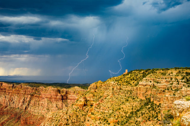
Lightning bridges the clouds above and fog below in Grand Canyon.Lightning bridges the clouds above and fog below in Grand Canyon.Lightning strikes the walls of Grand Canyon near Desert View Tower.
I went to Grand Canyon early and was photographing storms shortly before 3 P.M. It was interesting and unusual because fog rapidly developed deep inside the canyon as the storms approached from the south. For a moment I wasn’t certain I would see anything in the reduced visibility. But close lightning bolts dropped from the cloud base above, through the clear air, and then disappeared in the fog in the inner canyon. It was really spectacular to see this.
Another storm dropped a lightning bolt into the canyon near Desert View Tower with multiple contact points. Wow!
A double rainbow over Palisades of the Canyon and Desert View Tower in Grand Canyon.A rainbow moments before sunset spans the canyon.
And then the rainbows arrived with some brilliant and colorful arcs of light over Desert View point. Finally, just moments before sunset, another rainbow stretched from the North Rim to the South Rim.
It was an amazing day.
12 September 2023
An early evening storm produced a lot of in-cloud lightning that lit up the thunderstorm at the same time that the setting Sun was illuminating it from the West. And all of this was reflected in the waters of Mormon Lake.
Thunderstorm after sunset near Mormon Lake.
13 September 2023
Storms were more isolated this day allowing for nice views of the convection. I was able to get several photographs of the storms over the Little Colorado River (LCR) valley as I was heading towards Grand Canyon. Late in the afternoon a short segment of a rainbow appeared over the LCR.
An early afternoon thunderstorm over the Little Colorado River valley east of Grand Canyon.Thunderstorm over the eastern portions of Grand Canyon.A short segment of a rainbow with Desert View Tower.
14 September 2023
I spent the late afternoon and early evening in Wupatki National Monument and was able to get some really great sunset photographs. There was lightning after dark but most of it was too far away for interesting structure and branching.
A burst of color on a rain shaft at sunset over Wupatki National Monument.Fading sunset colors over Wupatki National Monument.
15 September 2023
Late afternoon and early evening storms were present to the west of Mormon Lake. I kept hoping for some dramatic lightning with sunset color–but only got the latter. It was still pretty good!
The setting sun illuminates a rain shaft over Mormon Mountain and Mormon Lake.
17 September 2023
I was actually trying to photograph Comet C/2023 P1 Nishimura but these clouds were in the way. This was taken well after sunset and the color was pretty remarkable.
Sunset colors on a mid-level deck of clouds.
So after a late start the monsoon season produced many photogenic opportunities for clouds, sunsets, fog, and lightning. And now the long wait until next season.
Previous posts on the 2023 North American Monsoon:
In a previous post I wrote how the North American Monsoon (NAM) was very late getting started in July. Fortunately, once started, it resulted in normal precipitation amounts for the month of August. Here are photographs and discussion of some of the events during the month.
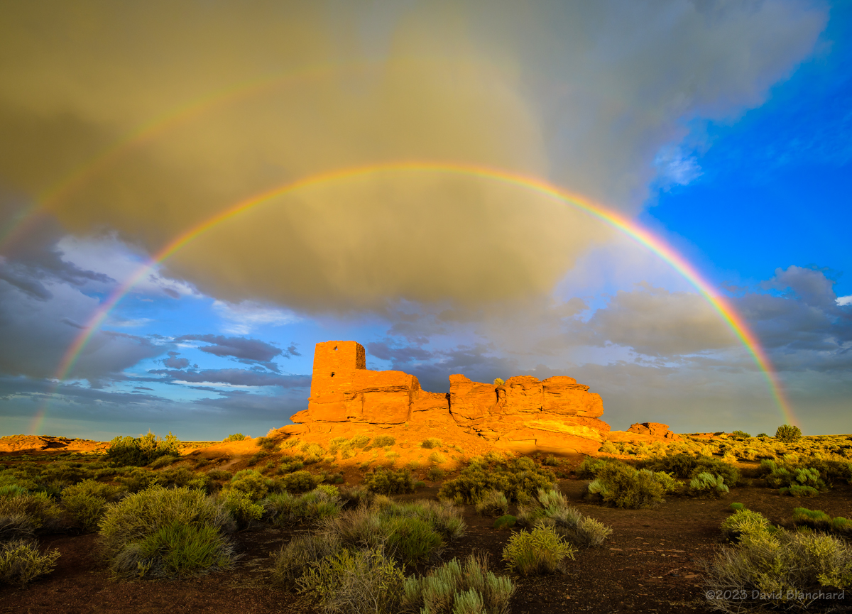
A double rainbow arches above Wukoki Pueblo in Wupatki National Monument.
The North American Monsoon (NAM) has been slow to get started this year. A general rule of thumb is it gets going around the 4th of July and is considered late (but still normal) by mid-July. Likewise an early start can occur as early as mid June–as it did last year.
Composite image of late afternoon lightning strikes over the grasslands of Wupatki National Monument.A segment of a rainbow over Wukoki Pueblo in Wupatki National Monument.Several lightning clusters that occurred during twilight at Wupatki National Monument.
During the month of July the GFS weather forecast model consistently showed the NAM getting started “Real Soon Now.” But the target was always several days away. Finally, late in the month the rains arrived as an inverted trough (IVT; def. 2) moved across Arizona.
Lightning over the San Francisco Peaks with Marshall Lake in the foreground.Lightning touches down deep in Grand Canyon.
There have been some photogenic storms. A little over a week ago I traveled to the South Rim of Grand Canyon hoping to get some lightning. Although there were some flashes they were far away. On the other hand, the sunset was pretty good. A band of clouds just above the horizon effectively blocked the Sun at my location while beams of light were getting under the clouds and into the canyon farther to the west. The alternating beams of light and shadow were pretty nice.
Beams of light and shadow filter deep into Grand Canyon.Beams of light and shadow filter deep into Grand Canyon.
The following day I went to Wupatki National Monument in hopes of lightning and rainbows. There was a late afternoon storm that moved towards the Monument and produced a lot of lightning. As it got closer it weakened but was still dropping rain and a short time later a beautiful, full double rainbow appeared. All I needed to do was position myself so that I could get the rainbow arch to frame Wukoki Pueblo.
Time lapse of convection developing over the San Francisco Peaks with Marshall Lake in the foreground.
A new storm formed to my southeast as twilight came on and began to produce a lot of lightning. This was the 3rd act of the day and it was a good one.
Later in the week I took a short drive to Marshall Lake near Flagstaff to time lapse the early stages of convection over the San Francisco Peaks–and with some reflections in the waters of the lake. A few lightning bolts landed near the peaks adding to the show.
A few more trips to Grand Canyon rounded out the month.