Here are some recent photographs of winter scenes in and near Flagstaff.
An early morning photo shoot near Mormon Lake.
A few nights of sub-zero temperatures provided enough ice for these locals to skate and play hockey on some water detention ponds.
Panorama of the detention pond next to the Sheep Crossing FUTS trail.Panorama of the detention pond north of the Sheep Crossing FUTS trail.Ice hockey on the frozen detention pond.
New Years Eve day brought widespread fog and low clouds to the area.
Low clouds and fog in Mormon Lake.Low clouds and fog on Forest Highway 3.
There was even enough snow for a bit of cross country skiing at Fort Tuthill County Park.
Skiing of Soldiers Trail at Fort Tuthill County Park.Snow-covered trees in Fort Tuthill County Park.Snow-covered trees in Fort Tuthill County Park.
More snow is expected later this week…more photos likely.
It’s always fun to head out at the tail end of a winter storm and capture photographs of the sunrise with the new snow. This winter has had only a few periods with real winter weather—the most notable was the last 10 days of December. Since then storms and snow have been infrequent.
Pre-sunrise sky over the San Francisco Peaks( 0724 MST 23 January 2022).First light strikes the San Francisco Peaks (0735 MST 23 January 2022).
Of course I was interested in taking advantage of our latest weather event—even though it was fairly weak and delivered only a skiff of snow. A quick check of satellite imagery before sunrise showed that skies were mostly clear and that there was a cap cloud on top of the San Francisco Peaks.
I arrived a bit before sunrise at the Mormon Lake overlook and started taking both photographs and video. The clouds were already dissipating over the peaks resulting in much less of a cap cloud than I hoped.
No matter—it’s always fun to out there before sunrise shooting photos. Here are a few photos from before sunrise and just after as the sun began to illuminate the peaks.
Below is a time-lapse video showing the movement of the clouds over the summits of the San Francisco Peaks.
Time lapse video (50x) of the sunrise over the San Francisco Peaks.
I was also intrigued by the tire tracks left in the snow of the parking area.
Tire tracks in the new snow at Mormon Lake overlook.
Finally—here is a sunrise photo from New Years Day—the last day in which we had significant snow here.
Sunrise over the San Francisco Peaks on New Years Day.
A strong storm system approached the southwest yesterday and moved through the state overnight. Ahead of the storm, clouds began to increase just before sunset and I found myself at the Mormon Lake overlook. The cumulus clouds were fairly shallow so that the sunlight hitting the tops of the clouds was scattered downward and provided some diffuse lighting and color to the cloud bases.
The setting sun faintly illuminates the meadows of Mormon Lake and provides some color to the field of cumulus clouds.A few minutes later and the sun is now illuminating the bases of the clouds.
There was also a thin gap between the clouds and the ground allowing for just a few minutes of direct sunlight.
Here are a few photographs of the sunset and clouds along with some sunlight spilling across the currently dry lakebed of Mormon Lake.
Band of showers and thunderstorms associated with the advancing cold front.
As the storm and cold front approached showers and thunderstorms quickly developed with a line of strong thunderstorms developing about an hour after sunset. There was quite a bit of lightning as the line of storms moved across the area. The sound of rain faded as it was replaced by snow falling in the wake of the front.
New-fallen snow lies on this cinquefoil plant.
In the morning there was snow covering the ground. Measurements were difficult as strong winds during the night had blown the snow such that some areas had a few inches and other areas were bare.
The snow juxtaposed with autumn colors was very pretty but my favorite photograph was the snow on this cinquefoil that still has some flowers.
A few days of tropical moisture—remnants of Tropical Depression Nora—brought widespread rainfall to much of northern Arizona. As the moisture was replaced by drier air in the middle- and upper-levels but was unchanged in the near-surface layer, we were left with a situation in which fog might form in the early morning hours.
So, up before dawn to drive out to Mormon Lake and the surrounding basin. And there was fog—at least in one corner of the basin. Here is a 30-minute time lapse compressed down to 17 seconds showing the movement of the fog as it sloshes back and forth.
Sunrise through morning fog.
As this was taking place, the sun rose through a shallow layer of fog.
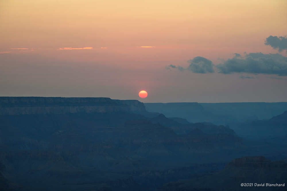
Sunset at Grand Canyon.
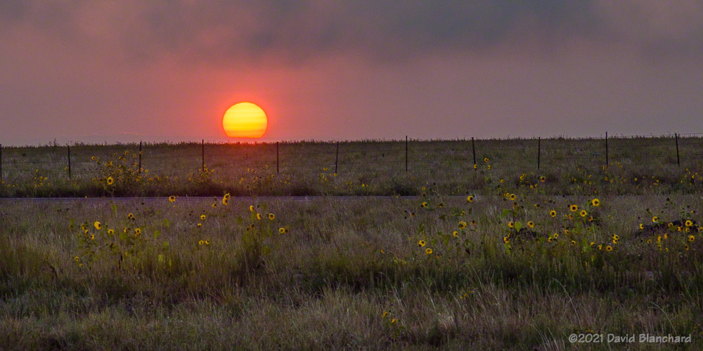
Bonus: on the previous evening the sun was setting through layers of smoke from the western wildfires.
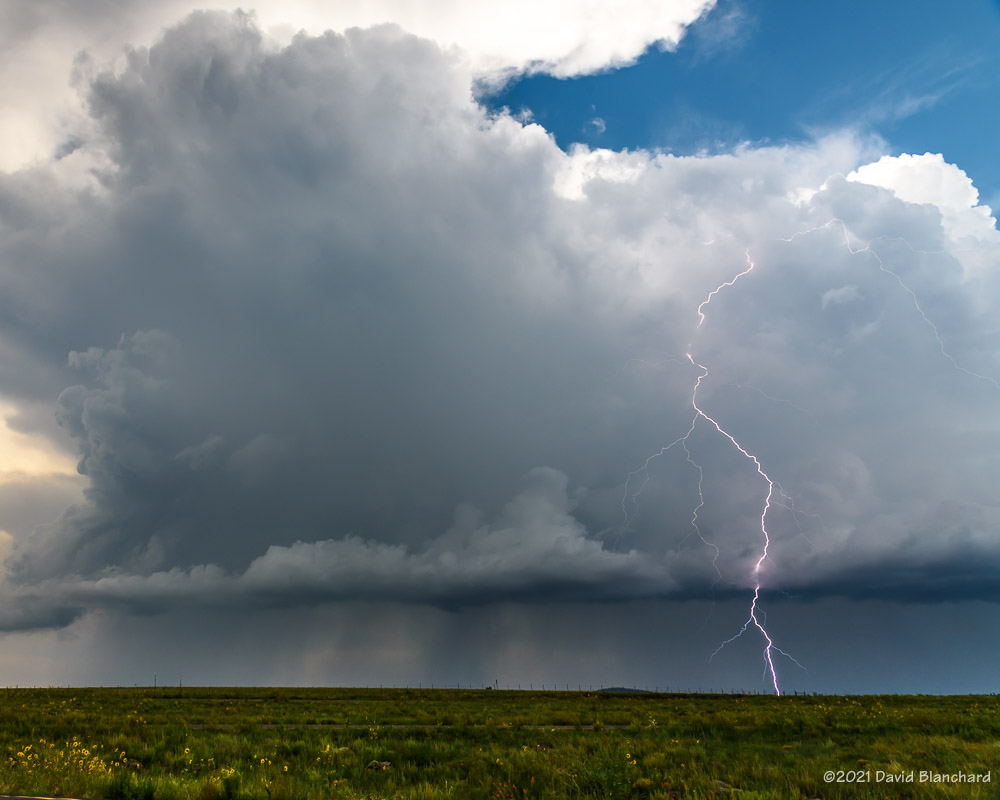
A slow-moving storm allowed me to get photographs of lightning and a bit of time-lapse video. The best lightning strike of the day was outside of the cloud and started near the top.
Lightning near Mormon Lake.
Below is a time-lapse video of the storm earlier in its life.